

As a complement to the Structural General Plan, definitively approved by the Valencia Territorial Urban Planning Commission on December 18, the City Council of Alpuente has approved the Detailed Ordinatión Plan (POP), drafted by AUG-ARQUITECTOS, SLP. This completes the complete review of the planning of this municipality, after more than seven years of work.
The Alpuente POP represents a huge improvement in relation to the previous planning, some Subsidiary Standards approved in 1990 and 24 specific modifications. The previous planning, as a whole, was drawn up with a perspective that is difficult to understand today and without any rigor in what refers to the organization of the different inhabited nuclei of this municipal term and that are, in addition to the town of Alpuente, La Almeza, Baldovar, Campo de Abajo, Campo de Arriba, La Canaleja, El Collado, Corcolilla, La Cuevarruz, Las Eras, El Hontanar and La Torre. The great urban interest of each of these villages and their specificities have determined the great complexity of this plan and the effort that has been necessary to implement to carry it out. For each of the villages, a summary of the different planning alternatives that have been considered is provided in the POP.
The POP report highlights that what has guided the drafting team and which must preside over any decision that may be adopted with respect to the future of the town, whether it comes from the local Administration or any other body, must be the need to articulate measures and models (in this case urban planning) to combat depopulation. If the European Parliament considers that areas with a population density below 8 inhabitants per square kilometre, in Alpuente, with a density of 4.59 inhabitants/km², compared to a provincial average of 239.85 (ARGOS 2020) and a gradual process of population loss, present an extreme risk of depopulation.
Faced with a very worrying demographic outlook, Alpuente has sufficient resources to guarantee its sustainability, it has a solid agricultural sector that must be preserved, it has mineral resources and it treasures a landscape and a heritage of extraordinary interest. The landscape, natural, paleontological, ethnological, archaeological and architectural wealth places this town at the head of the municipalities with the most relevant and varied heritage in the Valencian Community. The state of conservation of this heritage and the sensitivity of the inhabitants of this land, who, with a few exceptions, have been able to maintain it and even exhibit it in two museums with great exhibition appeal and scientific rigor, are solid elements on which to base the proposals of the plan.
The specific objectives that the new plan pursues, with regard to detailed planning and in addition to what is generally included in article 35 of the VALENCIAN URBAN PLANNING LAW (TRLOTUP), are the following:
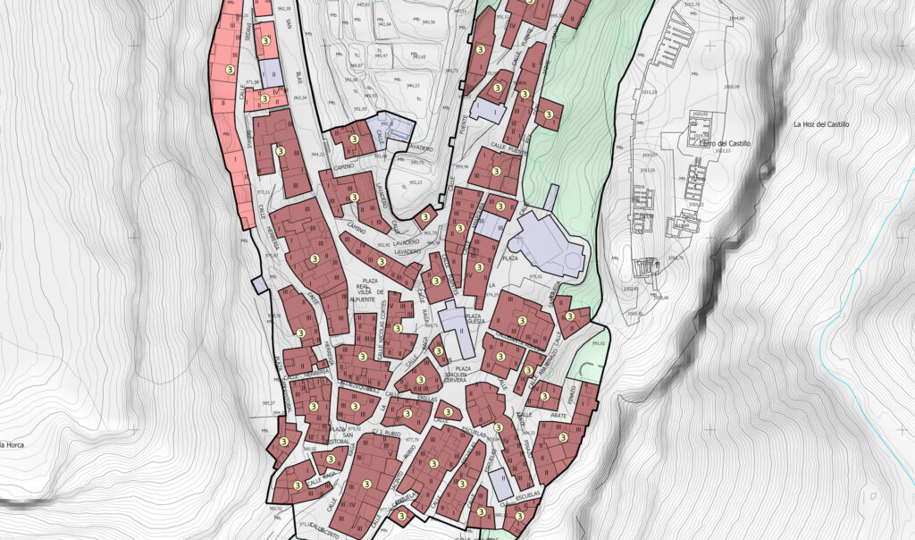
- The identification of all local heritage and its protection in the corresponding Protection Catalogue, so that its preservation is guaranteed, appreciation and respect for it by residents and visitors is encouraged, and this wealth is interpreted as the basis for promoting quality cultural and leisure tourism. With regard to the assets protected within the framework of detailed planning, that is, the catalogued assets, it should be noted that the catalogue protects 979 elements of all kinds distributed in 302 files.
- The incorporation of urban planning regulations adapted to all current sectorial regulations, supra-municipal protection figures (Natura 2000 Network) and current, proven and rigorous criteria for regulating this type of area. In non-urbanizable land, establishment of the typological conditions of the permitted buildings and constructions and the characteristics of the fences, taking into account the rich heritage legacy of dry stone, dispersed throughout the area. Likewise, the POP determines the specific technical standards for the replacement of trees, widening of paths, cleaning of the premises, purification of waste and discharges, as well as other standards with a similar purpose. It also determines the delimitation of the layout of the livestock routes as they pass through urban or urbanizable land, in accordance with the applicable sectorial regulations.
- The delimitation, in accordance with article 35.1.i) of the TRLOTUP, of an execution unit, between the new development zone, already consolidated, in Las Eras and the residential development land sector SR-01, “Las Eras”.
Collaterally and as a consequence of the tools used and the exhaustive knowledge of the current planning that AUG-ARQUITECTOS, SLP has, as the company that authored the Consolidated Planning Text of Alpuente (2023), with the POP the serious graphic and cartographic problems detected in the current planning have been corrected. These problems, which were not only attributable to precision errors or the tools used in its drafting, generated a space of legal uncertainty in the structural and detailed planning determinations that have been corrected with the approval of the LP, opening a horizon full of possibilities for this municipality.