
DESCRIPTION
The municipality of Rotglà i Corberà, in the region of La Costera, in the Cañoles River Valley and on its left bank, is the result of the merger of two previous ones, called Alcudia Blanca and Corberà, the first of which would later take the name of its territorial lord, José Rotglà. There are evidences of occupation of the territory since the Metal Age: they are the remains of a possible town of the Valencian Bronze culture that exist in the Alto de la Carraposa, in part already in the term of Llanera, where smooth ceramics made to flint hand and chips. There are no data from the times that go from the Bronze Age to the Romanization, but from this last period, apparently from the 1st to the 3rd centuries of the Era, there are the remains of an important rustic town: walls, paving slabs, loom, ceramic of Iberian and Roman tradition of common type.
Roman and pre-Roman sites have also been found. It is possible that they were part of the villas around Saetabis (Xàtiva), which stood out for the quality of their linen.
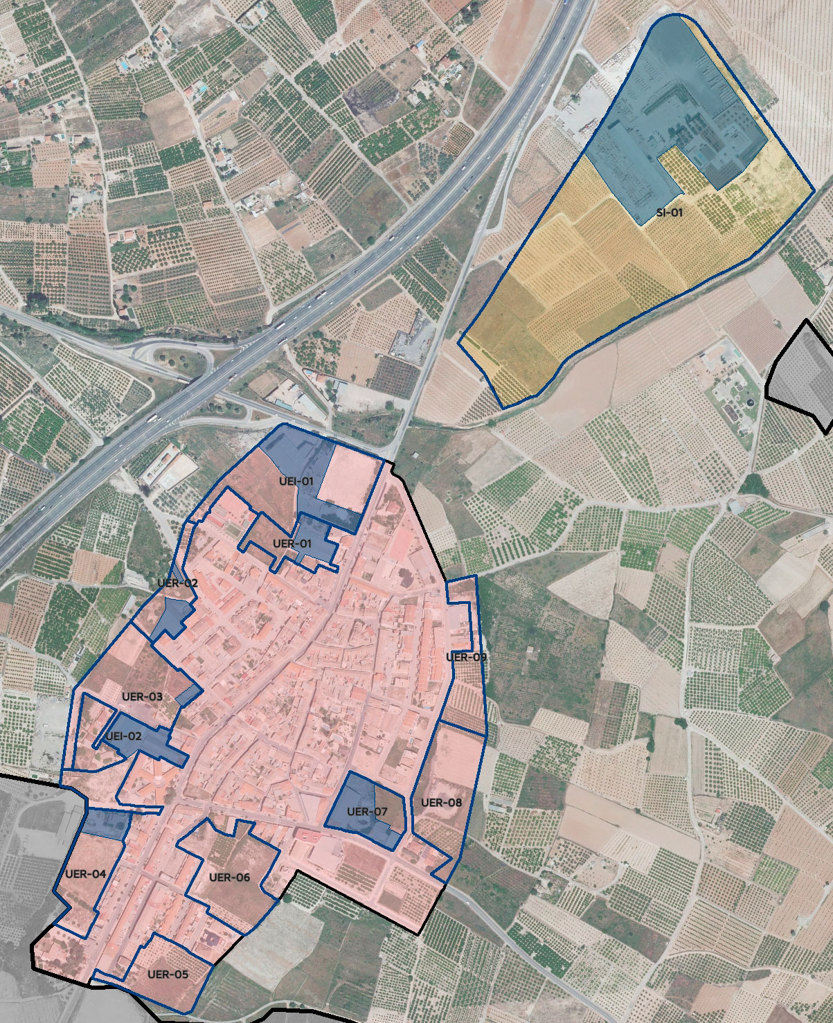
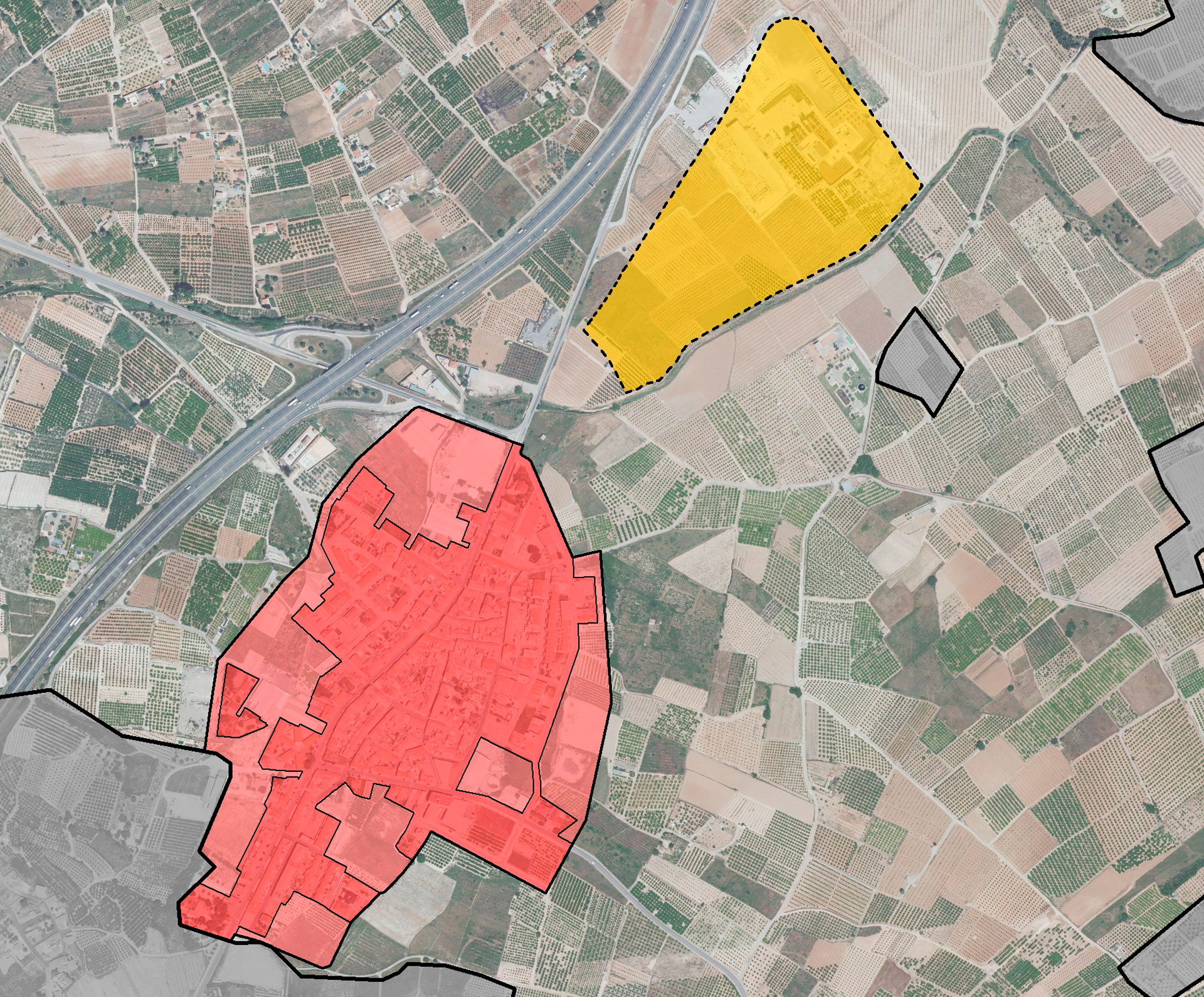
Rotglà i Corberá currently shares mobility problems with neighboring municipalities that go beyond the content of a general plan, as well as the effect of the occupation of part of its territory by illegal housing. Within the urban area, the presence of industrial buildings constitutes an element of degradation, which is difficult to escape from because of the jobs that depend on these facilities and because of the extraordinary difficulties to be overcome in trying to take these industries out of the area and locate them. in a polygon with that use.
After almost three decades of validity of the current planning and after suffering the declaration of nullity, in 2014, from a PGOU which had been approved in 2008, the main objectives of the new general plan are:
- From an environmental, economic and landscape point of view, the attribution to a large part of rustic land, of the degree of protection that is its own and necessary to safeguard its values.
- From the point of view of supra-local sustainable mobility, the provision of a reserve space for a road of communication or variant of the old national highway, to the east of the towns of Cerdà, Torrella, Llanera de Ranes and Rotglà i Corberà, which will allow the intense traffic of vehicles heading north to be diverted, seeking the connection with the A-7 motorway. Collaterally and also as an expression of the improvement of sustainable urban mobility in the initial stages of planning, the provision of a network of pedestrian and cycle routes, linked to roads, streets and highways, that favors this type of transits and access to work centers, without the need to use motorized transport.
- The adequacy of the growth forecasts for the sealed soil to the thresholds established in the ETCV and to the real expectations of the municipality, from a containment perspective, which necessarily entails the reduction of the developable land foreseen in the PGOU canceled.
- The forecast of new productive land in sufficient quantity to favor, in the shortest possible time, the transfer of productive activities outside the urban area, for the majority residential use, so that in the medium and long term, It tends to clearly differentiate the area for housing and public endowments from the area for industries.
- Lastly, and anticipating detailed regulations, Rotglà i Corberà must recover the protection of the quality of the built heritage, so that far from renouncing any control of urban aesthetics (as the current NNSS have enshrined), the new plan comes to regulate a type of buildings inspired by vernacular architecture, in which without renouncing a contemporary language, stop the introduction of solutions of all kinds, alien to the morphology and compositional guidelines of the architecture of the region .
- The integration of Green Infrastructure within urban land, as a connecting element with the surrounding spaces and complement of the infrastructure indicated at the structural level.
- The progressive transfer to areas specifically qualified for productive uses, of factory buildings or warehouse use that currently coexist with residential use. The transformation of these soils into lots destined for housing.
- The programming of industrial land for development, subject to the burdensome loads to which we have just referred, but whose achievement is transcendental for the improvement of the urban quality of the municipality.
- The improvement in urban mobility, relying on the alternative border road to the current crossing, which is proposed in the P.G.E.
- The protection of the urban landscape, introducing ordinances that preserve the architecture of the Traditional Historical Center and avoid, in areas of new growth, the proliferation of all kinds of aesthetic solutions. An attempt will also be made to improve the quality of the urban edges and facades, avoiding voids, the appearance of party walls and any transgressing element, whether due to its improper character, excess volume or architectural inadequacy.
- The incorporation of urban planning regulations adapted to all the sectorial regulations in force and to the specific circumstances of the municipality, with an indigenous architecture that must be preserved, without thereby preventing the rooting of the population and the execution of works on the built heritage.
- The delimitation, in its proper measure, of the provisions regarding green areas, school equipment and homes subject to some protection regime.
- The guarantee of access to housing, in the terms established by current regulations.
- The preparation of an inclusive plan, which takes into account the most disadvantaged groups and in particular, the elderly, with an increasing weight in the municipality as a whole. A plan that also favors sustainable mobility, even allowing access to the industrial sector through a bicycle path, independent and safe.
DETAILS OF THE PROJECT
Locality: Rotglà i Corberà (Valencia, Spain); Promoter: City Council of Rotglà i Corberà; Municipal term area: 627 Ha.; Urban Land: 36 Ha.; Able for urbanise Land: 12 Ha.; Not able for urbanise land: 579 Ha.; Population cores: 1; Processing status: In process